 F4LUFTBILDER
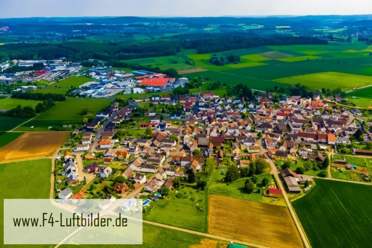


Borsdorf on the edge of the Wetterau fields
In Borsdorf the red roofs are arranged in a comparatively compact group. Shortly behind the last houses, the Wetterau's agricultural landscape opens up. The shape of the place can be captured particularly well when an entire field can be seen in the foreground.
The outskirts of town as a motif
In the series about Borsdorf, the green foreground varies in width depending on the direction in which it is viewed. A wide strip emphasizes the village's island location in the field. A narrower one leaves more room for branches within the town.
A village view needs a comprehensible starting point. This can be an intersection, a prominent group of houses or the end of a street. From there, the paths to the outskirts of town can be more easily followed in the image. When publishing for readers from outside, a brief location information in the caption helps. Resident viewers are often interested in another level. They are looking for the location of a house, the route of their route to school or a familiar open space between buildings.
Field boundaries as a benchmark
On a map, fields become similar areas. In the aerial photo they differ in color, structure and processing direction. A bright dirt path divides two plots, a row of trees interrupts the straight lines. In such places, the size of the open hallway is better understood than by just looking at the horizon. Color changes should initially be left as an observation. Which crop is growing in a field or when it was cultivated can often only be determined from a single photo with additional local knowledge.
What becomes visible on the edge of town
On the edge of town, several scales come together in a small section. On one side there are individual buildings with gardens and driveways. On the other hand, a single open area sometimes takes up as much space as several streets. This change can be shown in the picture over a common edge. A section in which the border between the two areas remains visible even when displayed narrowly is suitable for a website. The motif then retains its local reference even in the mobile view.
Warm tones within the series
For a direct image comparison, use shot 2 and shot 5 from the gallery with 5 aerial photos. In the second view, warm reds and browns have more weight than in the first. Red-brown and yellowish areas are particularly noticeable next to cooler surfaces. What is interesting when comparing is whether they are concentrated on a single object or appear spread out across the entire view.
According to camera data, Shot 3 and Shot 1 were taken on May 23, 2019. There is a gap of less than a minute between the two images. ISO 100 and an exposure time of 1/400 second are recorded for both files.
A moving view is also available. Under Aerial videos you can find the clip “Borsdorf in Hessen - Aerial video of Borsdorf”. The linked preview leads to inclusion in the aerial photographer's portfolio on Adobe Stock.
A townscape for chronicle and community
For a local chronicle, the outer edge of the development is just as interesting as the middle. That's often where things change first. A meadow becomes a building site, a driveway is given a new route, a single house disappears behind the larger trees. If you want to talk about the same place again later, a dated overall view is helpful. You can agree with the aerial photographer on a point that should remain in the image when repeated. A street intersection is usually better suited for this than a moving object on the side of the road.
Related motifs in the aerial photo archive
The article Berstadt offers another perspective. Berstadt stands out in the overview due to its densely built-up core and the longer rows of houses towards the outside. In the gallery Altenstadt there is a different focus. In the aerial photos of Altenstadt, the transition to open fields is clearly defined.