 F4LUFTBILDER
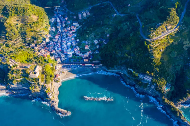


Monterosso between beach and rock
At Monterosso the bay directly adjoins the steep slopes of the Cinque Terre. The narrow built-up zone can be clearly seen from the water. A wide perspective connects the beach and settlement with the darker rocks that border the coastal section.
The narrow space by the water
In Monterosso, rock and beach provide two different shaped boundaries of the town. The row of houses is easier to follow on the open beach than on the indented slope.
The two sides of a bay do not have to take up the same amount of space in an aerial photo. Often the closer headland obscures part of the opposite bank. A higher view opens up the space in between and shows the transition to open water. This makes a second view particularly valuable for depicting the location. While one image explains the location on the coast, the other can show the sheltered interior area, where the course of the shore and the use of the land are more clearly visible.
The narrow zone between land and water
From a low angle, a beach often looks like a narrow, light fringe. The bird's eye view reveals its actual shape and shows where it widens or ends at a protrusion. In addition, connections to the hinterland emerge. The section where a path or buildings reach the beach can be particularly interesting for a townscape. There the location can be specifically named and the individual motif can be found within a longer stretch of coast.
The slope of a landscape
It is difficult to estimate how steep a slope is from a top view alone. A street that rises in curves or the staggering of neighboring buildings gives the eye additional clues. The relief becomes even more vivid if part of the valley floor or the bank remains in the picture. Anyone who selects a recording for a location description can pay attention to this connection. It helps to understand the position of individual subjects without having to estimate height differences from the apparent distance in the image.
Warm tones within the series
Among the 3 photos in the gallery, shot 1 and shot 3 provide a good starting point for the comparison. In the second view, warm reds and browns have more weight than in the first. Red-brown and yellowish areas are particularly noticeable next to cooler surfaces. What is interesting when comparing is whether they are concentrated on a single object or appear spread out across the entire view.
The camera captured September 29, 2020 for shot 1 and shot 3. The time interval between these two views is approximately 5 minutes. The exposure time was 1/200 second for the first of the images mentioned and 1/640 second for the second.
Select the coastal view for a photo series
When telling a story about a coast, the order of the images counts. A further look first explains the course of the bank. A closer view can then show the transition from land to water. If an image series begins with a narrow section, readers usually need an additional location reference. The planned size is also important for the aerial photographer. A small indentation can be a clear reference point on a double page spread and almost disappear completely in a narrow column. The caption should match the actual section used.
More aerial photos for comparison
Two further articles invite comparison. In the first, Cinque Terre, a different detail is in the foreground. In the Cinque Terre, small settlements punctuate the sequence of steep coastal slopes. After that, Saranda is a good option. In Saranda, the buildings move up the slope from the water in several stages.