 F4LUFTBILDER


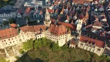
Sigmaringen's castle above the Danube
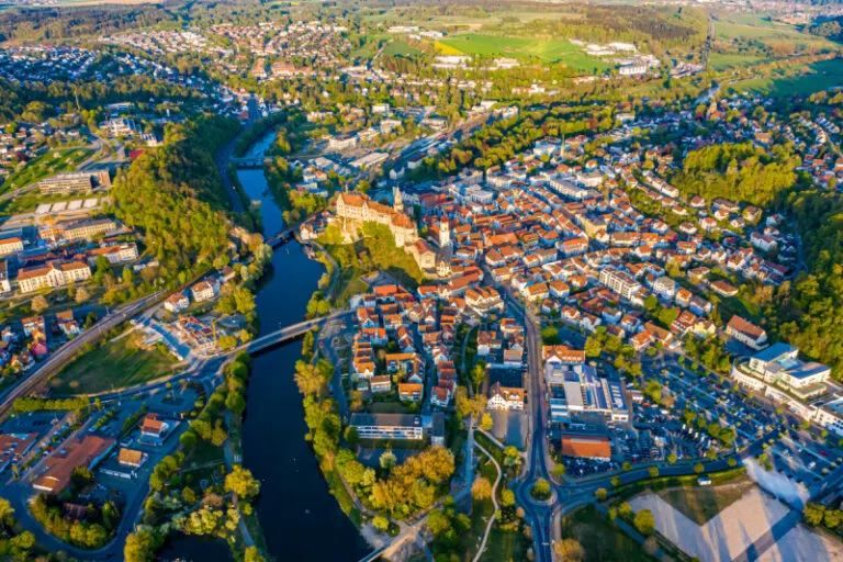
In Sigmaringen, the castle occupies a rocky outcrop on the Danube. The densely staggered buildings appear high from the river, but from above they combine to form an elongated complex. The neighboring houses give the striking building a clear comparison size.
Castle rocks and bank developments
In Sigmaringen the rock is part of the image of the castle. With the Danube at the bottom of the view, the sequence of water, rock and architecture can be followed directly.
The system can be told from two distances. The overview first clarifies how much space the building takes up on its hill or on the bank. The view then turns to a characteristic corner, the transition between two wings or the opening to a courtyard. This order is clear for an editorial article because readers can find the detailed section on the overview image. This is particularly helpful when multiple towers or wall edges obscure each other in a single view.
Follow the watercourse in the picture
At the river it is worth taking a second look at both edges of the picture. Sometimes a road ends there and continues along the water in the next section. In another place, a line of trees frames a stretch of bank. Such clues connect the place with its river valley. For a double page spread, you can choose an overview showing the course and juxtapose it with a close-up view of the shore. It helps if at least one bend in the bank or a building can be found in both motifs.
The shape of the rock in the light
Rock surfaces are often harder to read in an aerial photograph than their sharp outline suggests. A dark area can be a deep crevice or just in shadow. The connection of several visible edges provides information. Where they converge and cover a surface, a spatial jump is understandable. A location with clear rock contours is suitable for publication with smaller images. In a larger format, the eye can wander more over the finer differences in the surface.
Warm tones within the series
If you browse through the 12 aerial photos, you can stay at shot 4 and shot 7 for a comparison. In the second view, warm reds and browns have more weight than in the first. Red-brown and yellowish areas are particularly noticeable next to cooler surfaces. What is interesting when comparing is whether they are concentrated on a single object or appear spread out across the entire view.
For Shot 12 and Shot 1, the same day is noted in the image files, April 25, 2020. The recording times recorded are about 9 minutes apart. The exposure time was 1/200 second for the first of the images mentioned and 1/160 second for the second.
The Aerial Videos section supplements the photos with 4 clips. The aerial photographer's photographs linked there include “Sigmaringen from the air”. The relevant video page on Adobe Stock can be opened using the respective preview.
Communicate architecture and location together
Anyone who has visited a building themselves often remembers the entrance and the first view upwards. In the aerial photograph, these exact areas can disappear behind a roof or a wall. A suitable caption helps to connect the tour experienced with the spatial overview. For an aerial photographer, planned use is therefore a good starting point. A view for a site plan needs clear outer edges. An image for the cover page may focus more on the interaction between the building and its surroundings.
Related motifs in the aerial photo archive
If you are looking for related motifs, you can start with Rechtenstein. At Rechtenstein, the Danube follows a forested cut. It's worth taking a second look at Neuburg am Inn. The Neuburg lies above the Inn at a significantly different altitude than the water.
Aerial photos of Sigmaringen
Aerial photography & aerial videos
Your aerial photographer for Sigmaringen and the surrounding area
F4 Luftbilder - Your specialist for aerial photography and aerial photography in Sigmaringen and the surrounding area. Benefit from our many years of experience and technical equipment and let us convince you of quick implementation and unbureaucratic processing. We look forward to inspiring you with breathtaking aerial photographs and aerial photos in Sigmaringen and the surrounding area.
Services
Aerial photos in 4K resolution
Aerial videos in 4K resolution
Individual perspective wishes
Including image editing
All necessary permits and insurance
Free access to Sigmaringen and the surrounding area
Your advantages
Direct contact person
No appointment required
Unbureaucratic & short-term processing
Pay conveniently by invoice: bank transfer & Paypal
Delivery of images conveniently via download
Order processing within 10 days
Request a quoteAerial photos of Sigmaringen – unique views of the city
The city of Sigmaringen from the air
The city of Sigmaringen is located in the southern German state of Baden-Württemberg. The city is known for its medieval core, Sigmaringen Castle and the many historic buildings. But Sigmaringen has much more to offer. The city is surrounded by beautiful countryside and there are many interesting places to discover. The best way to explore the city and its surroundings is by helicopter. From above you can see all the beauty of the city and its surroundings. There are many different aerial photos of Sigmaringen, but these 10 are particularly impressive: 1. Sigmaringen Castle towers majestically above the city and is particularly impressive to see from above. 2. The medieval core of the city is also very impressive from above. You can clearly see the narrow streets and the many historic buildings. 3. The Rhine Bridge is another highlight of the city. From above you can clearly see how the bridge crosses the river. 4. The Danube River winds through the entire city and is particularly beautiful to see from above. 5. The surrounding landscape is also very impressive. From above you can see the green meadows and fields stretching into the distance. 6. The Hohenzollernburg is another attraction in the Sigmaringen area. From above you can clearly see how impressive the castle is. 7. Hohentwiel Castle is also very impressive to see from above. You can clearly see how the castle sits on the mountain and rises far above the surrounding area. 8. The town of Tuttlingen is also very interesting to look at from above. You can clearly see how narrow the streets in the old town are and how many historical buildings there are. 9. The town of Rottweil is also very interesting to look at from above. You can clearly see how narrow the streets in the old town are and how many historical buildings there are. Rottweil is particularly known for its medieval market square with the half-timbered town hall and the Gothic collegiate church “Zum Heiligen Kreuz”. 10. The town of Ravensburg is also very interesting to look at from above. Ravensburg is particularly known for its medieval market square with the town hall from the 14th century and the Gothic St. Mary's Church.
Unique views of the city
The city of Sigmaringen offers unique views of the picturesque landscapes of southern Germany. The city lies on the edge of the Swabian Alb and is surrounded by a number of lakes. This environment offers breathtaking views of the city and its surroundings. Aerial photos of Sigmaringen are a great way to admire the beauty of the landscape. The shots show the city in all its glory, from the picturesque buildings to the green landscapes. Aerial photography offers a unique view of the city and its surroundings and is a great way to admire the beauty of nature.