 F4LUFTBILDER
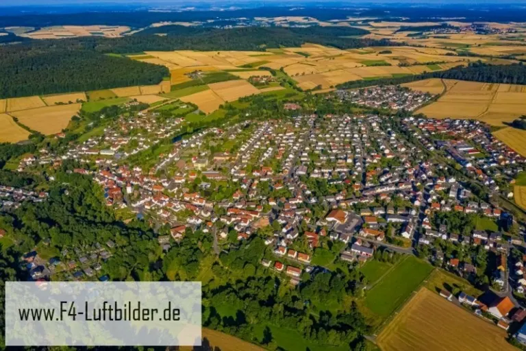


Bad Emstal at the foot of wooded slopes
The Hessian community of Bad Emstal is seen from above as a series of built-up areas between fields and forest. In the overview, the transition from the last street to the yellow-green field is particularly striking. It illustrates the proximity of living and landscape.
Field boundaries on the edge of the settlement
At Bad Emstal, the distance to the forest can be described by the width of the fields that lie between the last buildings and the slope. Such location information is immediately comprehensible in the image and does not require estimated meter values.
The location in a valley is made clear in the aerial photo by the lateral boundaries. A nearby slope pushes forward in front of a distant one, and the valley floor opens up in between. If the section is too narrow, it can easily give the impression of a flat surface. A shot with a bit of a slope at the edge of the image preserves the context. Orientation is particularly successful when there is also a familiar size comparison, such as a street or a house. The eye can then better assess the depth between the individual landscape levels.
What becomes visible on the edge of town
On the edge of town, several scales come together in a small section. On one side there are individual buildings with gardens and driveways. On the other hand, a single open area sometimes takes up as much space as several streets. This change can be shown in the picture over a common edge. A section in which the border between the two areas remains visible even when displayed narrowly is suitable for a website. The motif then retains its local reference even in the mobile view.
Field boundaries as a benchmark
On a map, fields become similar areas. In the aerial photo they differ in color, structure and processing direction. A bright dirt path divides two plots, a row of trees interrupts the straight lines. In such places, the size of the open hallway is better understood than by just looking at the horizon. Color changes should initially be left as an observation. Which crop is growing in a field or when it was cultivated can often only be determined from a single photo with additional local knowledge.
Warm tones within the series
To switch between two of the 10 aerial photos, shot 7 and shot 8 can be called up directly in the gallery. In the second view, warm reds and browns have more weight than in the first. Red-brown and yellowish areas are particularly noticeable next to cooler surfaces. What is interesting when comparing is whether they are concentrated on a single object or appear spread out across the entire view.
Shot 1 and Shot 10 are among the views from July 23, 2019. According to the camera's time information, there are approximately 4 minutes between the two images. ISO 100 and an exposure time of 1/1000 second are recorded for both files.
A moving view is also available. The clip “Bad-Emstal in Hesse from the air” can be found under Aerial videos. The linked preview leads to inclusion in the aerial photographer's portfolio on Adobe Stock.
Select landforms for a landscape portrait
A single contour line can shape the impression of a landscape and yet reveal little about its extent. For a printed panorama, it is worth looking at the widest view first and then at a section of the same area. In a small format, a foreground with a clear contour can become more important than the most distant peak. If you plan a new view with an aerial photographer, you can make this decision based on the intended page layout and clarify in advance which part of the landscape definitely belongs in the picture.
Related motifs in the aerial photo archive
Two additional views can be used in the archive for comparison. The first can be found at Bad Hersfeld. Bad Hersfeld almost changes color when you look at it from above. The second belongs to the article Bad Soden. Above Bad Soden, the distant buildings are lost in the haze, but the houses in the foreground remain easily distinguishable.